
🏔️ Summer break: go ahead and order — shipping resumes Wednesday, 22 July.


MountainCarto
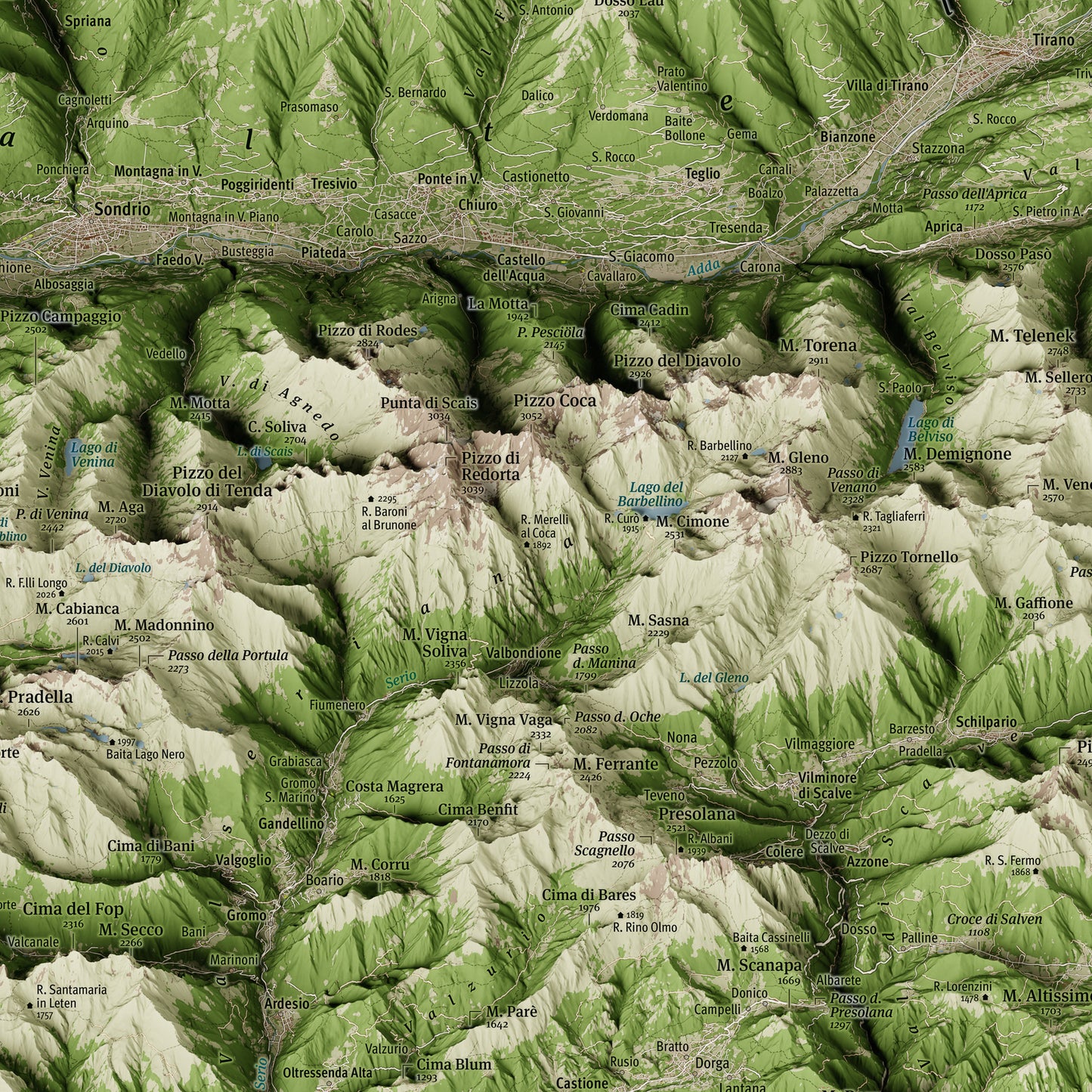
Bernina · Ortles · Adamello – Panoramic Map in Oblique Projection
Bernina · Ortles · Adamello – Panoramic Map in Oblique Projection
Couldn't load pickup availability
The Italian Alps in a single view
This map covers one of the most vast and fascinating alpine territories in Europe: the Italian Alps almost in their entirety, from the Swiss border to the gates of Trentino, with three great mountain systems brought together in a single sheet.
The Bernina group with its glaciers, the Ortles-Cevedale with its 3,905 metres, and the Adamello-Presanella with its great glacial plateau. Completing the map are the Orobie Alps, rarely given the space they deserve, and the great alpine valleys that run through this territory: Valtellina, Val Camonica, Upper Engadine, Val Venosta, Val di Sole, Giudicarie, Val Brembana and Val Seriana.
Produced in oblique orthographic projection, it combines cartographic precision with visual realism to render volumes, ridges and glaciers in a natural way — like a true panoramic view over the alpine landscape.
The result is a faithful and evocative three-dimensional image, made for those who love the mountains and want to bring home a sweeping vision of the Italian Alps.
Perfect for:
- Those who love the Bernina, the Ortles or the Adamello and the mountains of the Italian Alps
- Hikers and mountaineers who explore Valtellina, Val Camonica or the Upper Engadine
- A special gift for anyone with a connection to Bormio, Livigno, St. Moritz, Ponte di Legno or the valleys surrounding these massifs
- Decorating contemporary homes and spaces with a bold yet refined presence, inspired by the great alpine peaks
Print details
- Size: 100×70 cm (39.4×27.6 in)
- Printing: high-resolution offset printing on glossy coated paper, 250 g/m²
- Finish: anti-glare matte lamination, for lasting protection
Available Options
Unframed Map – the map is shipped rolled inside a sturdy protective tube.
Oak Frame Edition – the map is enhanced by a frame featuring a natural oak finish and a clean, understated design, crafted and assembled by hand in Tuscany, Italy.
Unlike traditional framed prints, there is no front glass or acrylic panel. The map surface is protected by a matte lamination that eliminates reflections and allows every cartographic detail to be appreciated with exceptional clarity and natural color rendering.
The map is mounted on a rigid panel with an aluminum core, a professional solution that ensures long-term stability and prevents warping over time.
Each piece is delivered ready to hang.
Shipping
Tracked shipping with email notification. Framed maps are shipped fully insured against loss or damage.
Italy: 2–3 business days · International: 3–5 business days
Created by
This map was personally created with care and passion by Marco Barbieri, cartographer and mountain enthusiast.
More information about cartographic data sources and copyright.
Share


Explore the high-resolution map
Regalo apprezzato! Ottimo prodotto.
gentilissimo il rivenditore: mi era arrivata danneggiata e me ne ha rispedita immediatamente una nuova senza nessun costo aggiuntivo! cartina bellissima