
🏔️ Summer break: go ahead and order — shipping resumes Wednesday, 22 July.


Mountain Carto
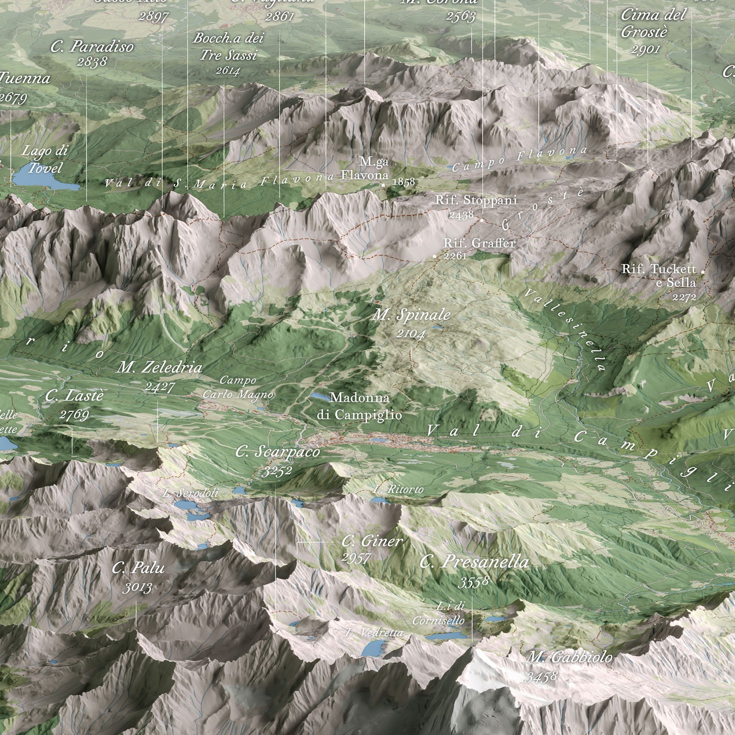
Dolomiti di Brenta – Panoramic views (East and West)
Dolomiti di Brenta – Panoramic views (East and West)
Couldn't load pickup availability
Two spectacular views of the Brenta Group
Discover the Brenta Group like never before: this map combines cartographic precision and visual impact through two oblique perspectives (East and West) that reveal the full north–south extension of the range. The inclined orthographic projection enhances vertical walls, glaciers, and valleys, offering a spectacular and technically accurate view.
Perfect for
- Hikers planning long traverses
- Geology and mountain landscape enthusiasts
- Interior decor for creative spaces, lodges, and curated interiors
Printing details
- 2 available sizes: 70×50 cm or 100×70 cm
- Technique: High-resolution offset printing on 250 g/m² glossy coated paper
- Finish: Matte anti-glare lamination for long-lasting protection
Available Options
Unframed Map – the map is shipped rolled inside a sturdy protective tube.
Oak Frame Edition – the map is enhanced by a frame featuring a natural oak finish and a clean, understated design, crafted and assembled by hand in Tuscany, Italy.
Unlike traditional framed prints, there is no front glass or acrylic panel. The map surface is protected by a matte lamination that eliminates reflections and allows every cartographic detail to be appreciated with exceptional clarity and natural color rendering.
The map is mounted on a rigid panel with an aluminum core, a professional solution that ensures long-term stability and prevents warping over time.
Each piece is delivered ready to hang.
Shipping
Tracked shipping with email notification. Framed maps are shipped fully insured against loss or damage.
Italy: 2–3 business days · International: 3–5 business days
Created by
This map was personally created with care and passion by Marco Barbieri, cartographer and mountain enthusiast.
More information about cartographic data sources and copyright.
Share


Explore the high-resolution map
Ottima resa, veramente accattivante per chiunque ami la montagna e.... le carte geografiche!
Spedizione veloce e mappa di qualità. Un ottimo regalo per un appassionato di montagna
Mi piace andare in montagna e ho sempre voluto una cartina ben dettagliata per programmare le mie gite. Ho trovato queste carte e le ho prese subito. Ottimo vederle da destra e sinistra. Suggerisco al signor Barbieri di aggiungere il rifugio Vallesinella e Casinei, punto di riferimento per le escursioni. Spero di poterle vedere in formato 3D in rilievo.
Ottimo acquisto.
Ho acquistato questa mappa perché fornisce una visuale particolare, panoramica e diversa delle Dolomiti di Brenta. La mappa è allo stesso tempo molto bella da vedere e molto precisa, con indicazione delle varie cime con le rispettive quote, segnate in modo moto chiaro e leggibile. Da appassionato di cartografia posso dire che non è sempre facile creare mappe che siano precise e allo stesso tempo belle da vedere. Questa mappa soddisfa bene entrambi gli aspetti!