MountainCarto
The Alps – Physical Wall Map of the Alps, A0 Size
The Alps – Physical Wall Map of the Alps, A0 Size
Then 10 € off every extra map — different titles count too. Applied automatically in your cart, on unframed editions.
Couldn't load pickup availability
<h2>The whole Alps in one map</h2>
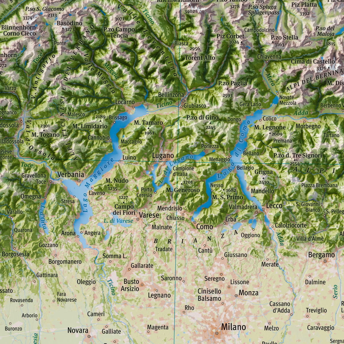
<p><strong>The Alps</strong> is a large physical wall map that shows the entire Alpine arc as one mountain range: <strong>from Provence and the Jura to Austria and Slovenia</strong>, together with the Po Valley, the northern Apennines and the coasts of the Ligurian and Adriatic Seas.<br>The map shows <strong>no national borders and no country names</strong>: the Alps are presented for what they are, one great mountain system shared by many countries and many languages.<br>The relief is shown in <strong>2.5D</strong>, with a three-dimensional effect that makes the relationships between valleys, ranges, massifs and plains easy to read at a glance. The result is an overview rarely found on a single sheet, designed to be a <strong>true wall piece</strong>.</p>
<h3>Ideal for:</h3>
<ul>
<li>Mountaineers and hikers who want to see at a glance where they have been and where they want to go</li>
<li>Anyone who loves the Alps and knows them from more than one side, across borders</li>
<li>Gifts for mountain, geography and map lovers</li>
<li>Homes, studios, offices, mountain huts, schools and exhibition spaces</li>
</ul>
<h3>What the map shows</h3>
<ul>
<li>
<strong>The entire Alpine arc</strong>: ranges, groups and massifs. Names were checked against the main Alpine classifications, but the map favours the names people actually use: a group is named when it has a well-known, recognisable name (Vercors, Bernina, Kaisergebirge); smaller groups without a common name are grouped under the name of the larger range that contains them (Alpi Graie / Alpes Grées).</li>
<li>
<strong>Limestone and crystalline rock</strong>: bare rock is shown in two colours. Limestone and dolomite are light grey; all other rocks, both crystalline (granite, gneiss, schist) and non-carbonate sedimentary (sandstone, marl), are a darker brown. This makes neighbouring groups easy to tell apart, for example the pale Dolomiti di Brenta and the darker Adamello–Presanella just to the west. The distinction is simplified from geological maps and shows the main rock type of each area.</li>
<li>
<strong>Glaciers, lakes and rivers</strong>, with the main Alpine valleys.</li>
<li>
<strong>Peaks and passes</strong> with their elevations, cities and valley towns.</li>
<li>
<strong>Multilingual place names</strong>: every name is given in the official local language, with no exonyms. Where an area has more than one official language, names are shown in the main ones (Bozen / Bolzano, Biel / Bienne); ranges, lakes and seas shared by areas with different languages show the name in each language (Alpi Giulie / Julijske Alpe, Mare Adriatico / Jadransko more); rivers take the local name in each language area they cross (Soča and Isonzo). Title and legend are in English, with a subtitle in four languages: <em>Alpi · Alpes · Alpen · Alpe</em>.</li>
</ul>
<h3>Explore it online</h3>
<p>You can explore the map in high resolution and zoom into every valley in the <a href="https://mountaincarto.com/en/pages/the-alps" target="_blank">interactive version</a>.</p>
<h3>Print details</h3>
<ul>
<li>
<strong>Size:</strong> 84 × 119 cm (A0)</li>
<li>
<strong>Scale:</strong> 1:800,000, Lambert Conformal Conic projection</li>
<li>
<strong>Printing:</strong> high-resolution offset printing on 250 g/m² matte coated paper. The matte surface avoids glare and gives natural colours.</li>
</ul>
<h3>Shipping</h3>
<p>The map is shipped rolled in a rigid protective tube, by tracked courier with email notification.<br><strong>Italy:</strong> 2–3 working days · <strong>Other countries:</strong> 3–5 working days</p>
<h3>About the map</h3>
<p>This map was personally created with <strong>care and passion</strong> by <strong>Marco Barbieri</strong>, cartographer and mountain lover.</p>
<p><a href="https://mountaincarto.com/en/pages/credits-and-data-sources" target="_blank">More information on map data and copyright</a>.</p>
Share